
")


Leisure in Torres Vedras


The Route of Vine and Wine is located in Torres Vedras county and runs in full of its 20 parishes, the Two Harbors. Renowned for its farms and wineries, this parish, according to many experts, reflects the best of what wine is produced in the county.
- Parish of Dois Portos
- Views: EM 248 – Torres Vedras – Sobral de Monte Agraço
- Type of Route: Small Route Circular
- Starting point and Arrival Ribaldeira
- Distance: 15 km
- Unevenness Retained: 410 meters
- Altitude: Max .: 213 m (km 12 – Couple of St. Peter); Min .: 65 m
- Duration: 5 hours
- Degree of Difficulty: Medium
- Advised Season: All
Cartography: Military Letter No. 375 from the Army Geographical Institute
The Route of the Atlantic is the second course Pedestrian a network of paths that is being implemented by the Municipality of Torres Vedras. This is a linear route, which lets you enjoy magnificent places, whether the urban space or the beaches that are lost sight of and follow all the way.
- Parishes: A-dos-Cunhados, Silveira and Maceira
- Hits: IN 561-1 Porto Novo – Santa Cruz or EN 247-2 Santa Cruz – Blue Beach
- Course type: Small Linear Route
- Starting Points / Departure Arrival: Porto Novo (Parking near the beach)
- Arrival Blue Beach (roundabout next to Hotel) or Departure: Blue Beach (roundabout next to Hotel)
- Arrival: Porto Novo (Parking near the beach)
- Total distance to go: 11.5 Km
- Altitude Maximum and Minimum Max .: 76 m (Alto da Vela)
- Min .: 1 m
- Duration: 4 hours, 8 hours with return
- Degree of Difficulty: Easy
- Advised Season: All year
- Cartography Military Letters of Portugal, the scale 1/25 000, paragraphs leaves. 361 and 374, of the Army Geographic Institute
Rota das Lapas is a circular route with a length of 17 km covering two leads, the PR3.1 about 8 km and 11 km with PR3.2. This separates into Matacães at Km 6, before the ascent to the windmills and walkers should follow the signs that will lead to return to Quinta das Lapas. The PR3.2 separates into Monte Redondo, next to the Church of the Holy Spirit, at Km 10 and walkers should follow the county road 575 until the Quinta das Lapas. Quinta das Lapas, one of the most beautiful in the region, classified by IPAR, as well as property of public interest, currently works as a center for drug addicts recovery. The whole house and gardens is one of the most significant examples of theatrical effects pursued by civil Baroque architecture, inspired by models of the Italian Renaissance scholars.
- Parish of Matacães and Monte Redondo
- Hits: IN 575: Monte Redondo »Matacães; EN 115-2: Torres Vedras »Monte Redondo; EN9: Torres Vedras »Alenquer.
- Type of Route: Small Route Circular
- Starting point and Arrival Lapas Grandes (Quinta das Lapas); Matacães (by the Board of Parish); Monte Redondo (with the Church).
- Distance: PR3: 17 Km / Total distance including extensions and variations: 21Km
- Unevenness Collected: +303 m; -303m
- Altitude: Max .: 303 m »Min .: 63 m
- Duration: 5 hours
- Degree of Difficulty: Medium Difficulty PR3 »PR3.1 – Easy» PR3.2 – Ages.
- Advised Season: All Year
- Cartography: Letter Military Portugal, series M 888, sheet No. 375- Geographic Institute of the Army
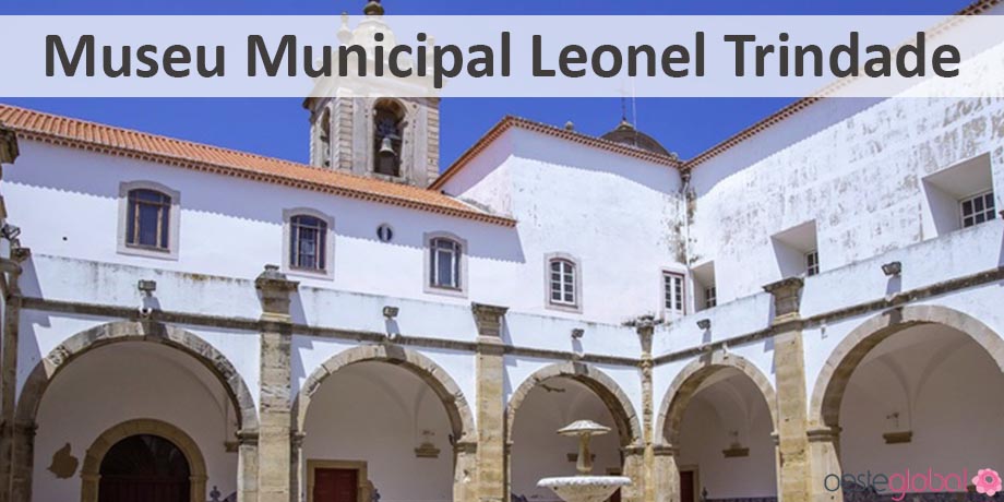
The Zambujal Castro Route is a circular route with a total of 16 km, having a shunt is created, the PR4.1 about 11.750km. The PR4.1 separates at Km 7, after Zambujal Castro, following Torres Vedras. Castro Zambujal is a fortified settlement of the Copper Age or Chalcolithic dating from the 3rd millennium BC Set on a rocky spur on the right bank of the Ribeira Pedrulhos, a tributary of the Rio Sizandro. Discovered in 1932 by Leonel Trindade, it was excavated along the 60’s and early 70 by the German Archaeological Institute. This is a Prehistoric fortification with four walls and towers and which had human occupation over at least 800 years.
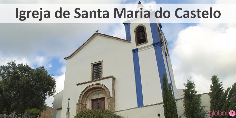
- Parishes of St. Peter and Santiago and Santa Maria do Castelo and S. Miguel.
- Access: A8: Lisbon Torres Vedras (Leiria); EN 8-2: Torres Vedras to Lourinhã, Peniche; EN 8: Malveira Torres Vedras, Bombarral; EN 115: Torres Vedras Cadaval; EN 9: Alenquer Torres Vedras, Mafra.
- Type of Route: Small Route Circular
- Starting point and Arrival Green Park Várzea- Torres Vedras
- Distance: PR4: 13 Km »Extension: 0.8 Km» Change PR4.1: 2.1 Km »Total distance: 16 Km
- Retained unevenness: 430 m
- Altitude: Max .: 185 m »Min .: 27 m
- Duration: 3 hours
- Degree of Difficulty: Medium.
- Advised Season: All Year
- Cartography: Letter Military Portugal, the scale 1/25 000, M series, sheet No. 374, of the Army Geographic Institute.
The Wind Route is a circular route with a total of 14 km, comprising a bypass, about 8 km. The start of the route is in the central garden in front of the Church of St. Luke in Freiria. From this location the walkers can choose to make the total route towards Chãos or towards the Serra da Serra do Pomegranates and Romeirão. The derivation is in the center of Freiria, next to Largo garden where an information panel and where the walkers can choose to perform the total distance of 14 km or only part of it 8 km or 6 km, depending on the option. Heading Chãos and passing Freiria Parish of the Board building turn left and cross the urban area bordering the Freiria in municipalities, from there prevails a constant agricultural landscape, including vineyards and vegetable greenhouses. The route is far will a dirt track to Chãos. It then follows up Fernandinho place to stop and sit next to the chapel, watching and listening to the still quiet country life. Walking towards Freiria, about 2 km, is the indication that will lead to the resumption of the route, near the Church of St. Luke and where you can choose to continue until the Serra da Serra do Pomegranates and Romeirão.
- Parish of Freiria.
- Access: A8: Arriving via the A8 motorway, exit at Malveira and follow the indication of Torres Vedras the National Highway 8. After passing the town of Freixofeira, turn right direction would stick / Freiria and take the road Municipal 554 to Freiria.
- Type of Route: Small Route Circular
- Starting point and Arrival: Church Square of St. Luke
- Distance: Total distance to go: 14 km; Derivation to 8 km’s or at 6 Km’s
- Unevenness Retained: + 259m; -271m
- Altitude: Max .: 194 m »Min .: 43 m
- Duration: 4 hours
- Degree of Difficulty: Medium
- Advised Season: All Year
- Cartography: Letter Military Portugal, the scale 1/25 000, M 888 series, sheets No. 374 and 388, of the Army Geographic Institute.
The route of the light is a circular path designated as Small Route (PR), with a total length of 23 km and can be converted into two paths: one 10.5 km’s and another 12.5 km’s. This is located in the municipality of Torres Vedras and runs in all of its parishes, the Bunker. Known as one of the oldest in the county, this town reflects the magnitude of the wine importance through its lush hillsides filled with the divine nectar of Bacchus.
While navigating the route that we propose can discover places of great historical, heritage and nature as the Church of Our Lady of Light, Valentine’s Square, the Chapel of Our Lady of Glory, the recovered mill Cuco, the Park 25 April, the Quinta do Paco, Fifth and Largo Bandstand D. Segismundo José de Menezes and Alarcão, the Chapel of Our Lady of Joy, the Chapel of the Mother of God (Zibreira), among others.
Town: Carvoeira
- Access: National Road 9 Torres Vedras »Alenquer – National Road 1080 Carvoeira» Village of Our Lady of Glory – Municipal Stay 374 Carvoeira »Careers
- Type of Route: Small Route Circular
- Starting point and arrival: Educational Center »Carvoeira
- Distance-To-Go: 23.2 Km’s
- Accumulated unevenness: path: + 237 m; -237 m
- maximum and minimum altitude: Max: 248m; Min: 86 m
- Duration: 6 hours
- Difficulty level:
- PR: medium / hard
- Variation: Easy
- Advised season: all year
Rota das Quintas is a circular route of 13 km in the parishes of St. Dominic of Carvoeira and Carmões. The route starts and ends in Carmões, through mainly rural areas, with particular emphasis on vineyards.
- Parish: Parish of St. Dominic of Carmões and Parish of Dois Portos
- Route type: Circular
- Starting point / Arrival Parish of St. Dominic of Carmões – Torres Vedras
- Distance: 15000 meters
- Unevenness Retained: 435 mt
- Altitude Maximum and Minimum: Max: 300 mt; Min: 105 mt
- Time: 3.5 hours
- Degree of difficulty: Easy
- Advised Season: All year
- Cartography: Letter Topographic 1:25 000 M888 Series No: 375
The Route of the Mills is a route that has its beginning near the old warehouses of Apple, the entrance to the Maxial, lower cretaceous of land, covering part of the “right road” to deviate to the right, starting to climb the mountains to the upper Jurassic land, which will develop most of this route.
- Parishes union Maxial and Monte Redondo
- Hits: EN 115-2
- Type of Route: Small Route Circular
- Altitude: Max: 363m | Min: 70m
- Grade Difficulty: Medium
- Advised Season: All year
- Cartography: Letter Military Portugal, the scale 1/25 000, M 888 series, sheets No. 374 and 388, of the Army Geographic Institute.
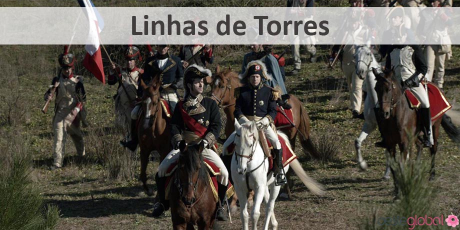
The Great Route Lines of Torres Vedras is a walking path that aims to inform the lines of defense, elaborate Arthur Wellesley, the future Duke of Wellington, who foreseeing a new Napoleonic invasion, along with the engineer José Maria das Neves Costa, organized the largest defense system in history, seated at 152 strong, with 600 pieces of artillery and military roads, all built between 1809 and 1812. Going through the parishes of Carvoeira, Two Harbors, Matacães, Monte Redondo, Rol Bridge, Runa, Silveira, Santa Mary, St. Peter and Santiago, St. Peter’s Chair, Turcifal, Ventosa.
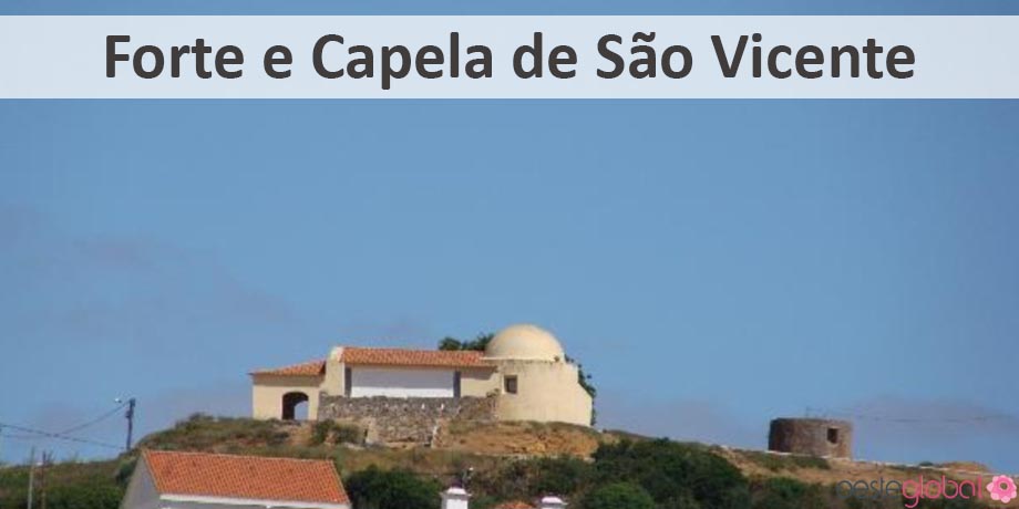
This starts at the Fort of St. Vincent, reaching the mouth of the Rio Sizandro or Lowland Green Park being the point of arrival in the Serra do Socorro. It has a total distance of 112 Kms – connecting to Sobral de Monte Agraço section of Mafra and Fort Cricket to Military Road in Bonabal Zone.
29km – Fort St. Vincent> Fort of Ordasqueira> Serra do Socorro
17km – Serra do Socorro> Castro Zambujal> Fort St. Vincent
21km – Fort St. Vincent> Fort Cricket> Foz do Rio Sizandro
26km – Foz do Rio Sizandro> Castro Zambujal> Fort St. Vincent
It has the following features:
- Mixed course type (linear and / or circular)
- Retained unevenness 2,350 mt
- Altitude Maximum and Minimum Max: 395 mt | Min: 5 mt
- Duration 2 days (total stretch)
- Degree of difficulty Mixed
- Advised Season All year
Cartography Topographic Letter 1:25 000, Series M 888 in 374, 375 and 389
- The Great Route Atlantic Way is a route that is inserted in the Great European Route E9, starting in St. Petersburg, Russia and ends in Cabo São Vicente. In Portugal, specifically in the West, its section – Natura West Network, has a length of 66 Kms between Assenta South Beach (Torres Vedras) and Cape Carvoeiro (Peniche) across the entire coast of the West. Natura 2000 is an ecological network which aims to conserve biological and ecological diversity of the Member States of the European Union. Throughout this network you can see the dune systems, the unique geological and paleontological structures, between the sea areas to marine birdlife.
Length of course: 3 days - Degree of difficulty: Easy
- Quota Reached Maximum: 95 meters (Montoito)
- Cota Minimum Hit 5 meters (Peralta)
Promoter: Municipality of Torres Vedras in partnership with Lourinhã Municipalities and Peniche