")


Nature in Alentejo
With excellent natural conditions with beauty scenery and with a great vocation for performing open-air activities, the Alentejo is proud to invite the most curious and interested to visit their lands, know their landscapes while walking on foot, mountain bike, car or even on horseback, by municipal roads that are also excellent for cycling. Rivers, reservoirs and Alentejo coast are great wonders for the nautical activities, especially beaches. Seeking to unite the more adventurous, skydiving, the paragliding, walks microlight and ballooning are some activities that Alentejo offers.
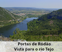
Tejo river
In order to discover an unknown Tagus, beyond its natural course which flows into the estuary that washes Lisbon, Alentejo allows to know this river through the Nisa region and then along the Belver.
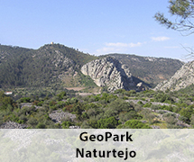
A municipality with a strong vocation for hiking, Nisa is one of the starting points for many walking paths, small route (PR) which you can see the landscapes presented with the Tagus and the S. Miguel saw. Of the 8 routes that exist and for those who have more time, there are three paths that show a bit of the beauty of Nisa and the Tagus River: PR1 “rails of Jans” beginning in Amieira do Tejo, has 12.6 kms; PR8 “White Mill rails” starting in Montalban, has 14 kms; and PR4 “Railing Conhal” has a beginning in Arneiro and go about 9.8 kms, this presents an incursion by the Roman Gold Mine, a heap consisting of piles of pebbles, this was made of gold extraction in Roman and medieval times. This site is part of the integrated geomonuments in GeoPark Naturtejo – one of the thirty European Geoparks classified by UNESCO.
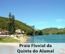
For those who like to go back to the forts and wartime, or just for those looking for a place for its beautiful views, Belver can find it all. At the highest point of the Belver Castle, you can see the panoramic landscape of the river Tagus and the River Fifth Alamal Beach, where canoeing activities are carried out, which then go to the Tagus meeting. Do not forget to walk the coastal path with 2 kilometers seated on wooden stakes, establishing connection between the bridge and Quinta do Alamal (PR 1 “Arribas do Tejo”).
To end any program in this area, perform a train ride along the Tagus, from Belver to Fratel, a section that becomes a great adventure Alentejo.
Serra de São Mamede Natural Park
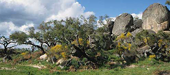
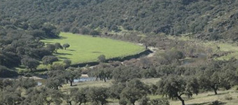
A frontier park is expressed by its exuberance. A very rich geologically park with its quartzite that mark the landscape with its megs sculptures. The north of the park, the chestnut and oak trees share their land with oak trees and holm oaks, as the vineyards and olive trees grow on the slopes that border the streams.
Even with human development in this area, the fauna of this abundant continuous park with its eagles of Bonelli and the griffin, the hawks, the toed waters, kestrel-gray, the eagle owl, owl-eating fox, among other birds live with wild boar, deer, badgers, mongooses, cats, mad, foxes and rabbits.
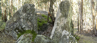
By going through this saw the man left traces of their presence, from dolmens, the menhirs, forts, Roman bridges, forts and sixteenth century, but most importantly, a network of sidewalks, where some are integrated in the footpaths of park. Currently, there are eight signposted routes, where your brochures with routes are available at the Water’s Eyes Quinta (park headquarters) in San Salvador Aramenha and Marvão and Arronches tourist offices. Some courses offer a unique adventure from the paths of Marvão, 8 kms, Galegos 11.5 kms, Alegrete with 11 kms, 16 kms Hope with, among others, have a fairly complete view of the Serra de São Mamede Park .
For those who seek to climb in this park, you can do it in Penhas de Portalegre, with unique and challenging walls. And for those who wish to discover the villages, towns and villages within the park, the roads are a real paradise to unravel.
Ecotourism without Fronteira
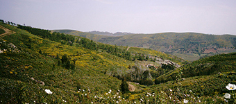
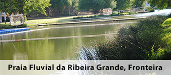
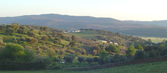
Between Frontier and Monforte, the landscape presents irresistible with its undulating and verdant meadows, rebanhados the sheep and wild cattle, their olive groves climb the hills neatly, the its cork oaks and oaks play with light and shade, while the vineyards change its colors and wild flowers follow the sun, painting the fields with the expulsions of seasonal colors. And in the valley of Ribeira Grande, thick vegetation flourishes along with the ruins of old water mills and historical remains such as caves-sanctuaries of S. Bento das Lapas, where several species of birds fly over them, something that is only discovered with those who venture on foot. Being possible through a route “Route of Ribeira Grande” begins and ends at Ecoturístico Centre of Ribeira Grande, along the border. Upon return, it is impossible to pass the river beach and at night, you must stop and observe the starry sky. Another longer route is the “Route of the Sierra Feathers” with 11 kms, lasting 3h30m, through the village of Cabeço de Vide, its historical center, the old lanes, tapirs Sierra Punishments and Sulphurous Spa.
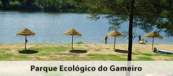
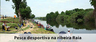
Among Gameiro and Maranhao, the Gameiro Ecological Park invites more interested to spend some leisure time and visit the Mora Fluviarium. Access to this is in Cabeção, a land with small wineries but with very good wines. The park integrates Açude Gameiro, a river beach where you can bathe, canoeing and walking gull, over 3 kilometers. For those looking to make sport fishing, the Raia river, offering an area of about 10 kilometers and two lanes, one with 200 fish and one with 65. This freshwater aquarium offers visitors a way “course of a river “along with an exhibition on the river fauna, from the source to the mouth, step by step, between rocky outcrops and sandy beds, there is a world to discover, ending with a small surprise made by fun otters, as well as the viewpoint of the landscape glass restaurant.
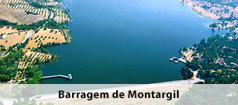
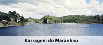
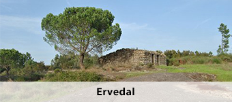
Montargil and Maranhão present their dams that mirror the clear water of the northern Alentejo, perfect for water sports. While Montargil undergoes a seaside resort, sought the good conditions for water skiing, sailing, windsurfing, rowing, hovercraft and sports fishing; the dam of Maranhão equipped with a leisure complex, in the city of camping together is another of the most beautiful places in the Alentejo, where the landscape is closely related to the heritage. On top of the lake, there is the town of Avis with its beautiful historic center that requires a visit. A simple and fun tour to do in this area Avis, Ervedal, Figueira and Barros and Benavila, advisable to be by car or bicycle to explore its nooks.
Serra d’Ossa
It is the main elevation of the Central Alentejo, with 650 meters of altitude, covering the municipalities of Estremoz, Borba and Redondo. The waters fed by the basin of the Guadiana and Tagus trickle down the slopes of this mountain. A slaty ground with an extension of marbles, called Zone of Marble, linking Estremoz, Borba, Vila Viçosa and Alandroal. Impossible not to explore this region, it is essential to assessing the landscape and visit the heritage, car, bike or on foot, there are trails that optimize the operation of the Serra d’Ossa.
For a first tour picks up the secondary roads that connect the urban core, recognizing that the best road to observe the craters of the marble exploitation is the one that connects Borba, Vila Viçosa and Bencatel, taking care of this road as there is movement heavy. In Vila Viçosa, it is advisable to visit the Marble Museum, which complements information on these farms. Walking through the historic centers of Estremoz region, Borba and Vila Viçosa, it makes visible the importance of marble to the heritage.
In the 60s, the Serra d’Ossa was eucalyptus plantation object, which formed the largest continuous area, with about 6,000 hectares, but in some areas, its original vegetation remained, including thickets of rockrose, heather, gorse and rosemary. To observe this vegetation are desirable paths “Routes das Antas” with 5.9 kilometers and the “Route Freixo” with 5.2 kilometers, both of great environmental, landscape and archaeological interest.
Axis from Évora to Montemor-o-Novo
A line that demonstrates its added value in terms of architectural heritage, but also offers a wide range for activities in nature, both in groups and in individual travel, particularly in Ecotrail of Évora, the Silver Water Route and Environmental Pathways of Monfurado and Cabrela.
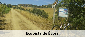
Can be traversed on foot or by bicycle, Ecotrail Évora resulting from the conversion of the old extension path of the railroad between Évora and Mora. Starting in the center of the city of Évora, extends to the county boundary, reaching Herdade da Sempre Noiva, covering a total of 21 kilometers. Another Ecotrail to ride or just walk, is the Mounted between the Tower of scythes and Montemor-o-Novo.
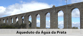
The walk of Água da Prata, the footpath runs along the Silver Water Aqueduct, a building that dates back to the sixteenth century and something over the years, was having reconstructions and improvements. Currently, still carries water to the city, presenting with an important heritage and environmental value.
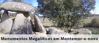
In Monfurado and Cabrela, are environmental pathways, integrated in the Natura 2000 network, which run through several rural villages of the districts of Évora and Montemor-o-Novo, discovering the reason for its environmental value and hence the rating. In these routes, there is a major megalithic monuments of this region, agricultural activities and forest-pastoris, related to cork oak, holm oak and olive grove.
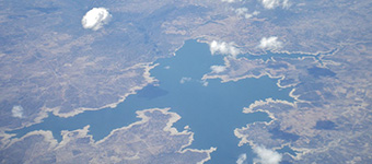
Alqueva lands
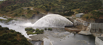
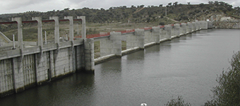
In a region where water was scarce, it was built the dam of Alqueva, on the Guadiana River between Moura and Portel, becoming the largest artificial lake in Europe, extending over an area of over 80 kilometers from the old course river and cuts totaling 1,160 kilometers of perimeter. In the downstream wall, the Pedrógão Dam was built, integrating the bridge that links Pedrógão, Vidigueira Moura.
What differs this reservoir from others? Its unique and typical Alentejo landscape, decorated by thousands of olive trees, cork trees and holm oaks, along with fortified heritage villages, erected to defend over the centuries. It is mandatory to all its surroundings on the right bank, Juromenha, Alandroal, Terena, Monsaraz and Portel and on the left bank, Mourão and Moura, explore their heritage and observe all the landscape of the Great Lake. In order to recall the memories of the old village submerged by the waters of Alqueva, the new village of Luz has in its museum a repository of memories and stories of this village and the river Guadiana.
In addition to sightseeing, this reservoir and surrounding sites feature a range of activities in addition to fishing, they are also made canoe trips or small motorized boats, several days of boat-house cruises, windsurfing, among others. For areas activities are provided helicopter activity of light aircraft and balloon. As for activities carried out on land, there are in addition to organized trips with walking routes to explore the surrounding nature, made both on foot and by bicycle, on horseback, charrette and jeep. For autonomous hikers, there are marked paths, including paths “route of the Giro”, beginning in the Church of Nossa Senhora da Consolação, has 4.5 kilometers to be covered; the “Alçada Stone” beginning on the Parish Council of Pias village, covering 9 kilometers; the route “trips by Field” by starting with the cemetery of Terena, with 11 kilometers to go; among other routes.
Noudar Nature park
In this Great Lake, Alqueva, Noudar is a special case, essentially requires a short detour worthwhile. Visiting the Castle of Noudar, taste the ham Barrancos and especially visit the Nature Park, built as part of the compensatory measures set out in the Environmental Management Program of Alqueva. This beautiful park is to promote a model of sustainable management of natural areas, joining the agri-environment agriculture and tourism, while respecting its natural values, such as the holm and birdlife, including raptors and vultures. This area is integrated in the Natura 2000 Impossible not resist this charm, the landscape of discovery can be made with three routes: the Rail Geological-Miner, the short walk Mount and the route Road, can be done walk and bike, with guides and digital guides.
When the return to Moira, is also essential pass in Amareleja, where it was built the largest Central Photovoltaics World.
Campo Branco
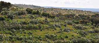
For those who like large open space and has enjoy birdwatching, Campo Branco, in Castro Verde, is the perfect place. White field is a very important region for the pseudo-steppe or cereal steppe in Portugal, this is an extensive cultivation area of dryland cereals, with fallow rotation system, and Campo Branco has one of the largest fields at this level. For this ecosystem to be sustainable, there is a dependency of many species of birds, including the great bustard, the lesser kestrel, the little bustard, the cortiçol-bellied-black, the crane and the Montagu’s harrier. Thus, their importance at national level, led to White Field is part of the Natura 2000. However, nothing can delight the greedy eyes that a walk through the signposted paths, specifically six walking routes, carried out by the League Association for Nature protection.
For those who want to, will have to schedule a visit at the Environmental Education Center Valley Gonçalinho – the heart of homesteads that the League for the Protection of Nature acquired under the Castro Sustainable Green project, with a minimum of 7 days in advance. A route that does not require marking the route is 6 “Valley Gonçalinho – Pereiras”.
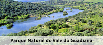
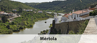
Guadiana Valley Natural Park
With an area of 70,000 hectares, this park extends between the area upstream of the Pulo do Lobo fall and the banks of the Basque, south of Mértola. A wonder that presents different landscapes, including valleys embedded River and tributaries, quartzite elevations of the Sierras de Alcaria and São Barão and an extensive plain and rough in growing arable rainfed, mounted oak and cistus area. An area with little human intervention, is still its Mediterranean scrub, ie, its original vegetation.
The Mértola village is the core urban center of this park, which local businesses help in promoting it through hiking, canoeing activities and small motorized boats ride in a stretch between Mértola / Pomarão and Vila Real de Santo António – It is regular or custom-made programs.
As many information available, it is advisable to trip on foot, by bike or by car to places like the Channel Mill, the Azenhas de Mértola, the Penha fishing Penha d’Águia and the stretch of the river that is only reached by Route the female firefighter.
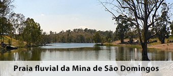
Other mandatory stop locations is Pulo do Lobo and the whole of Mina de São Domingos, Porto Pomarão and Fluvial Beach Tapada Grande.
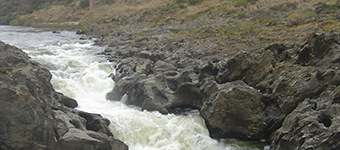
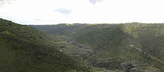
In Pulo do Lobo, this geomorphological accident in the Alentejo, made the last glaciation, the Wurm, which in the final stage resulted in a decline in the level of the sea. At that time, at the mouth of the river, which is currently the Guadiana, it formed a drop that was the result of a wave of regressive erosion, which was slowly moving upstream, digging a new bed inside the old bed. When he reached a more hard rock, called greywacke of Pulo do Lobo, erosion stopped – so getting this water fall of 14 meters on the serene Pego of the Shads. A clear and rare view of geologically distinct seasons, which formed the two beds of the river, while a bed is wider and carved in stone that ran the old Guadiana and more dug inside is the new bed with an extended rectilinear corridor with 12 kilometers long, called “Corredoira”. The whole story with millions of years of erosion, transformation and modification causes Pulo do Lobo is a must visit.
- Access the left bank in Mértola road – Serpa, near the Vale do Poço village.
- Access the right bank on the road Mértola – Beja, from Corte Gafo.
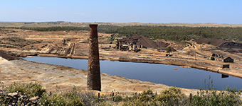
Mina de São Domingos, Pomarão port and the Tapada Grande River Beach – the largest pyrite mine in the Iberian Peninsula, the Mina de São Domingos offered work to more than 1,500 miners, while explored since the mid-nineteenth century, the British firm Mason & amp; Barry, ending its work in 1960. the mining district continues to tell the story of the miners, through their descendants and the British Palace, where they lived the directors of the operating company, has now become a hotel.
This mining complex met its rapid degradation but found its transformation into a hub of Industrial Archaeology and is signaled and your circulation is free, its Geological-Mining route extends between the cuts and the sulfur factories of Achada do Gamo. Heading Cambas Santana, about 10 kilometers, which corresponds to the old path of the railroad that transported the ore to the port of Pomarão, on the Guadiana river. It is currently a marina.
Even in front of the British Palace, the Hotel Santo Domingo, is the river beach of Tapada Grande, where the water that bathes the beach, is renowned for its quality for bathing and joining the small port of pleasure, with picnic area , an amphitheater and free bar air, who visit this beach is a perfect place to rest and enjoy a alentejano historic moment.
Pedrógão and Pulo do Lobo Dam
Outside the Guadiana Valley Natural Park, it is essential to visit the Guadiana river stretch that extends upstream between Pulo do Lobo and Pedrógão Dam, one of the most expressive vivid memories of the old river. Its natural beauty, landscape, along with the avifauna, the bucolic atmosphere of the water mills, currently disabled, falls into the openings of dams and river rapids small, animate an entire visit, both on foot and by bicycle or even with canoes. One of the most appropriate point to observe this wonder is the Serpa bridge, reaching the village of Quintos. For those in the area, be sure to visit the Historic Centre of Serpa and taste the renowned Serpa sheep cheeses.
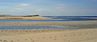
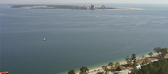
Shoreline of Alentejo
A permanent fascination ready to be discovered, the Alentejo coast is with the sea and the contrast appears between the blue ocean and the typically Alentejo colors. With its history and natural life, which earned the rating of three zones as protected areas: the Natural Reserves of the Sado Estuary and the Santo André and Sancha Lagoons and the Natural Park of Southwest Alentejo and Costa Vicentina.
Skirting with the coastline, are found the marshes of the Sado Estuary and between the tip of Troy and the Cape of Sines, the sand bath is uninterrupted by the Atlantic Ocean. For the interior, there is the lush greenery of the Sierra de Grândola, where the cork oak forest shares its space with large pine wood stains, while the rivers rushing down, reaching the beautiful lakes and give life to the extensive rice paddies . South after Sines, the cliffs were carved by the sea and wind, as time did these your chisel, cutting schist blocks, raising dune cords, which make and unmake the beaches and defining the contours of vegetation, Spiced plateau coastal and fed life.
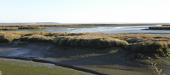
Santo André Lagoon
Santo André Lagoon along with the Lagoa da Sancha, on the coast of Santiago do Cacém and Sines, are one of the most important coastal lagoon systems in biological aspects, ecological, ichthyological, botanical and ornithological. Accompanied by its dune complex, which protect them, supporting and preserving the flora and fauna, including endemic species that are most vulnerable. The shipping line carries a high ecological value due to their weaknesses and specific dynamics, from the faunal communities in these ponds are areas passage of dolphins and birds. Covering an area of 5370 hectares, over 15 kilometers, from the southern village of Santo André Lagoon north of the area of the complex of Sines, extending a land strip of 2:03 kilometers and a maritime range of 1 , 5 kilometers.
Currently, this area is subject to various factors of pressure on their natural environment, particularly in the form of effluent emissions, hunting, fishing, tourism, human footprint and construction, which are imposed conservation measures and classification as a nature reserve. Since there are more than 106 species of aquatic birds and 112 species of land birds, more than a flora to protect, there is a sensitive ecosystem that requires full attention and care.
Sado Estuary Reserve
This reserve is an area of 23,160 hectares, of which about 13,500 hectares of estuarine area and 9,500 hectares are marginal wetlands converted to salinicultura, fish farming and rice cultivation. This area consists of a richness that extends from saltwater vegetation, the marshland and wildlife species that take refuge in this set, from the white storks, herons, the leg Long, spoonbills, the pink flamingos , birds of prey, ducks, tailors, European otter, the mongooses, the deer and dolphins and other species along with the human heritage. A protected area that can be visited and can enjoy its unique beauty with its natural, landscape and cultural heritage, and consolidate knowledge about its value, flora and existing fauna.
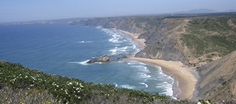
Costa Vicentina Natural Park
Created in 1995, this park was a Protected Landscape Area, which saw its importance be elevated to the Natural Park of Southwest Alentejo and Costa Vicentina, covering the coastal strip of Sines, Odemira, Aljezur and Vila do Bispo. With a diverse landscape, this park extends over 74.786 hectares, in which the importance of its cliffs, woods, ponds and temporary water lines, is a European level. The coast line level, this area is part 2 kilometers of coastline, already on the ground are its high cliffs and its escavas and deep gullies beaches, waterways, moorland, irrigated fields and production forests.
With regard to the Alentejo region, this park is the only one to receive the white stork and which nests in sea cliffs, also welcoming otters using the marine environment to search for food and receives a large number of migratory birds, with an area of recognizing important national and international level.
The flora found on the coast of southwestern Portugal has a cross influences North Atlantic, Mediterranean and Africa, which blossomed the ecological conditions and the very diversity of fauna and flora of this park, in a complementary sense, give a great natural wealth the Portuguese coast also requiring a great protection and conservation.